This website uses certain cookies, pixels and similar tracking technologies in order enhance site navigation, analyze site usage, and assist in our marketing efforts.
Certain information collected by that technology may be shared with our third party partners.
By continuing to use this website, you agree to the use of these technologies.
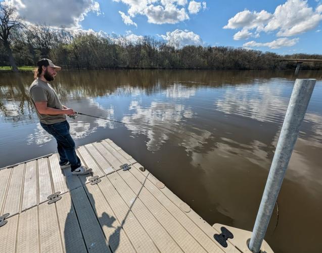
����Vlog��ý Resident Elmer Updike fishes on the swollen Rock River from a pier at Traxler Park near downtown ����Vlog��ý on Thursday afternoon. Rock County officials began mobilizing self-serve sandbag stations in the town of Rock and Newville amid predictions by the National Weather Service that the Rock River could reach moderate to severe flood stage in parts of Rock County by late next week. Predictions are that the river could reach 11.7 feet at Afton by April 23, the highest flood crest the river’s seen here since 2019.
����Vlog��ý Resident Elmer Updike fishes on the swollen Rock River from a pier at Traxler Park near downtown ����Vlog��ý on Thursday afternoon. Rock County officials began mobilizing self-serve sandbag stations in the town of Rock and Newville amid predictions by the National Weather Service that the Rock River could reach moderate to severe flood stage in parts of Rock County by late next week. Predictions are that the river could reach 11.7 feet at Afton by April 23, the highest flood crest the river’s seen here since 2019.
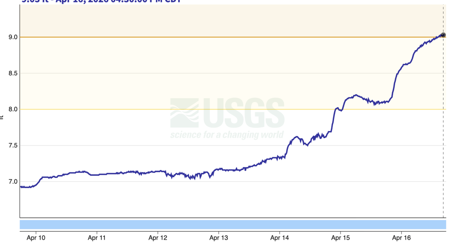
The water level at the USGS monitoring station in Afton continued to climb with heavy precipitation all week.
JANESVILLE — The Rock River is under a flood watch after days of rain have soaked the ground and filled tributaries. Extended forecasts say the river could jump to nearly 12 feet at Afton by next week — a prospect that’s prompted the county to activate sandbag-filling stations in Newville and the town of Rock.
The United States Geological Survey’s river gauge at Afton shows the Rock River had reached 9 feet as of early Thursday afternoon. That puts the river at minor flood stage.
The National Weather Service has declared a flood watch for parts of the Rock River, including the Afton area, through at least Saturday, with longer-term predictions that the Rock River could crest at at least 11.7 feet at Afton by late next week.
The river’s surge comes after the region saw 4 to 6 inches of rain over the last week. Rain and thundershowers are expected to continue through Friday. As of Thursday morning, the Rock River has reached the highest levels seen since July 2024, when USGS data shows the river hit 10.8 feet.
Rock County Emergency manager Kevin Wernet said the river is on the same track as it was in mid-2024, and, in fact, parts of Rock County could see flooding that’s considered significant.
“It does look like based on the (National Weather Service’s) forecast that (Lake) Koshkonong would go to major flood stage” by next week, Wernet said.
Wernet said the county has activated a sandbag-filling station at the Newville Park and Ride off Interstate 90/39 at mile marker 163, for residents in the north part of the county — along with a sandbag-filling station in the town of Rock town hall, 5102 S. County D, for state line residents.
He said both stations are “fill-your-own.” The sand and bags are provided, but people must bring their own shovel and transport their own filled bags.
Wernet said people who might need to sandbag their property should read the on on the proper way to fill sandbags and how to set them in place so they actually block flood waters and protect property.
He said people can track the river’s rise over the next several days by checking the National Weather Service’s .
Right now, the river’s stage means some localized flooding of low-lying crop fields near the river.
Higher river levels like those seen in mid-2024 — ones in the 10.5- to 11-foot range — typically cause more disruptive flooding of a few local roads and some low-lying urban parks alongside the river.
In 2019, the river reached 11.2 feet at Afton, an event that triggered major flood advisories and sandbagging efforts.
That still falls well short of the 13.51 feet the river hit at Afton in 2008 — the highest on record in modern history.
The 2008 flood caused widespread damage and destruction of several homes in a low-lying subdivision on ����Vlog��ý’s northwest side — and left carp swimming on Main Street as the river surged over the downtown’s seawall.
Sign up for our Daily Update & Weekend Update email newsletters!
Get the latest news, sports, weather and more delivered right to your inbox.